Tag: Cyclone Mocha

  • Cyclone Mocha makes landfall along Bangladesh, Myanmar coasts

    Cyclone Mocha makes landfall along Bangladesh, Myanmar coasts

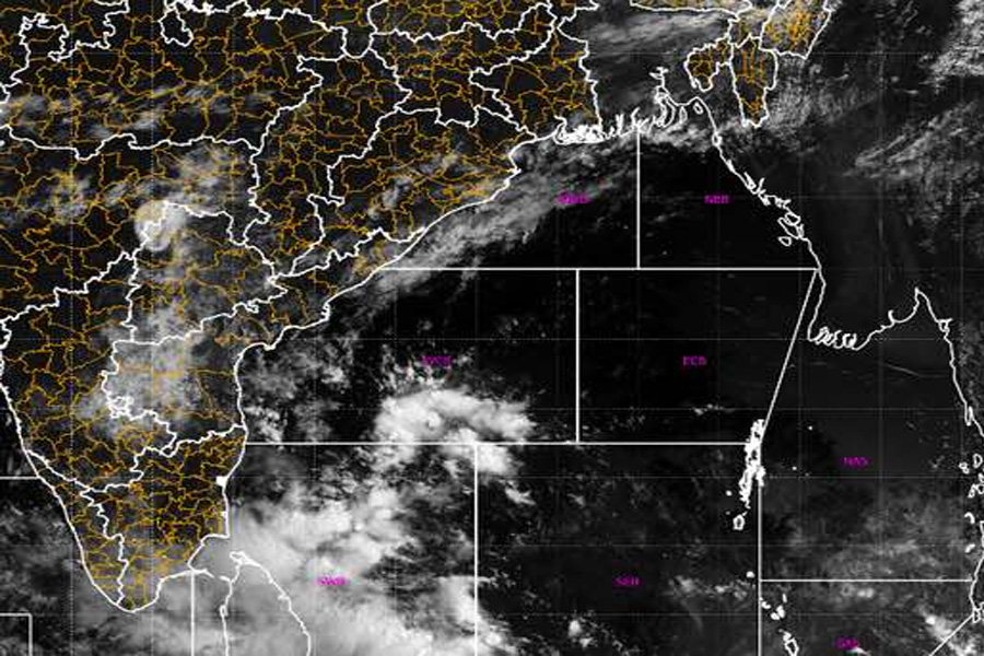
    DHAKA: Super cyclone Mocha made landfall along the Myanmar-Bangladesh coasts on Sunday after intensifying into the equivalent of a category-five storm, a senior Met official said. The powerful made landfall shortly after midday on the Teknaf shorelines before making its way through the Naf River that divides Bangladesh and Myanmar.

    “The ‘eye’ or the centre point of the cyclone made its landfall shortly after midday today on the Teknaf shorelines, coming through the Naf River, ahead of its anticipated time,” Bangladesh Met office spokesman AKM Nazmul Huda told PTI.

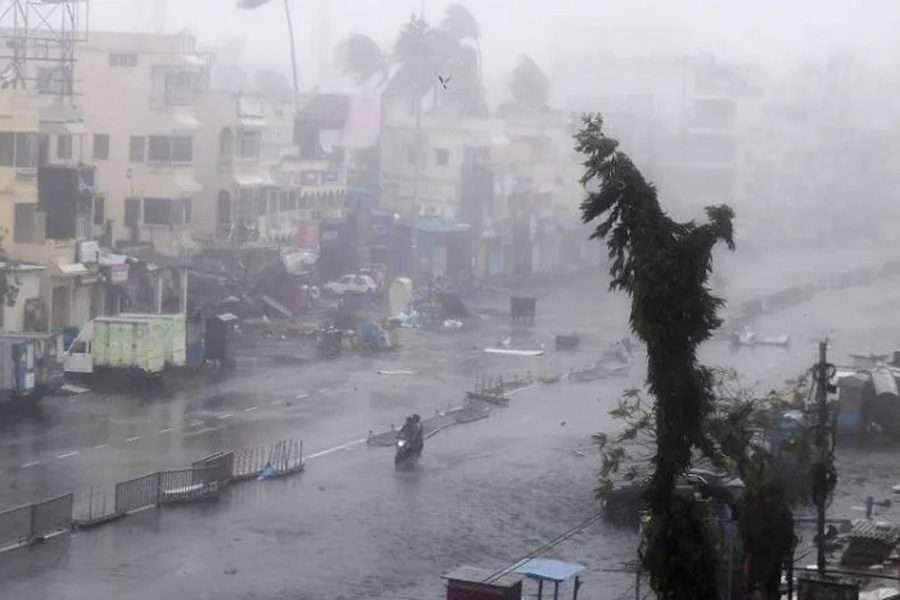
    He said the tail or the rest part of the severe storm, which was categorised as a very dangerous category-five cyclone, might take more time to cross the coastlines. Administrative chief of Teknaf sub-district of Bangladesh’s southeastern Cox’s Bazar Mohammad Quamruzzaman said the wind was blowing at a speed of over 200 kilometres per hour in Taknaf and its southernmost part Shahpori Dip along the Bay of Bengal. Teknaf is close to Myanmar and separated from northern Myanmar coasts by the Naf River.

    “The weather is frightening because of the very high velocity of wind but we are yet to see the much-feared massive tidal surges,” Quamruzzaman said.

    The weather officials said the Naf River was currently witnessing high tides that began at 11 am and would continue until 5 PM (local time).

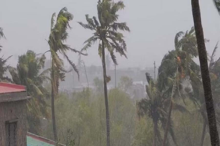
    The officials and residents in Cox’s Bazar said cyclone Mocha was bringing with it heavy rain and winds of up to 195kph and feared it may lead to dangerous flooding in areas around the Bay of Bengal.

    Storm surges of up to four metres could swamp villages in low-lying areas. There are fears it may hit the world’s largest refugee camp, Cox’s Bazar, where over one million displaced Muslim Rohingya refugees live in makeshift camps.

    Earlier, the Bangladesh Met Office issued the highest danger signal 10 for Cox’s Bazar.

    Cyclone Mocha started hitting the coastlines of Bangladesh and Myanmar on Sunday after intensifying into the equivalent of a category-five storm.

    The powerful cyclone brought heavy rain and winds of up to 195 kph.

    The forecast was it will make landfall with heavy rains and winds on Sunday afternoon.

    The low-lying areas of Cox’s Bazar and Chattogram are likely to be inundated by wind-driven tidal surges eight to 12 feet above normal.

    Tidal surges of five to seven feet above normal are also likely to deluge low-lying parts of Feni, Noakhali, Laxmpur, Chandpur, and Bhola, bdnews24.com reported.

    Meteorologists previously warned Mocha could be the most powerful storm seen in Bangladesh in nearly two decades.

    Around 500,000 people have been evacuated to safer areas by the Bangladesh government.

    As part of its preparation, Bangladesh shut nearby airports, ordered fisherfolks to suspend their work and set up 1,500 shelters as people from vulnerable areas were moved to safer spots.

    Officials said the government, with the support of UN agencies and aid workers, has kept tonnes of dry food and dozens of ambulances ready with mobile medical teams in sprawling camps of the Rohingyas who fled to Bangladesh from Myanmar.

    Residents and officials fear the Mocha-triggered tidal surges could cause massive deluges and landslides, endangering the lives of those residing in hillside camps, where mudslides hit regularly.

    The World Meteorological Organisation, a United Nations agency, has warned the super cyclone will cause heavy rain, flooding, and landslides around the coasts of Bangladesh and Myanmar.

  • Cyclone Mocha: Why The Name & IMD’s Prediction On Its Probable Path

    Cyclone Mocha: Why The Name & IMD’s Prediction On Its Probable Path

    Bhubaneswar: Amid the forecast that there is a good chance that the low pressure over the Southeast Bay of Bengal will produce a cyclonic storm, national media reported that Cyclone Mocha might make a landfall on the eastern coast of the country.

    Citing India Meteorological Department’s (IMD) Thursday predicted, the India Today said that the storm is likely to make landfall in Odisha, West Bengal between May 7 and May 9.

    According to the IMD, a cyclonic circulation is likely to develop over Southeast Bay of Bengal around May 6. Under its influence a low pressure area is likely to form over the same region around May 9. It is likely to concentrate into a depression over Southeast Bay of Bengal on May 8. Thereafter, it is likely to intensify into a cyclonic storm while moving nearly northwards towards central Bay of Bengal. The details of its path and intensification will be provided after the formation of low pressure area, it added.

    “No prediction has been made about the path and intensity of the possible cyclonic storm yet. We have not made any prediction about its impact on Odisha. We will speak about it once the low pressure forms,” IMD DG Mrutyunjay Mohapatra said on Friday.

    Times Now reported that the system over the Bay of Bengal would intensify into a cyclonic storm in Chennai and surrounding areas this weekend.

    The IMD in its Tropical Weather Outlook issued on Thursday said that IMD-GFS weather model indicates that the system may move towards Bangladesh-Myanmar coast and intensify into very severe cyclonic storm category. While the cyclonic storm may take shape around May 9, the model indicated north-northwestwards movement till May 10 and northeastwards recurvature thereafter towards southeast Bangladesh and adjoining Myanmar coasts.

    According to European Centre for Medium-Range Weather Forecasts (ECMWF), the low pressure over Southeast Bay of Bengal may form around May 7, Depression over the same region and adjoining South Addaman Sea around May 9 with gradual north-northwestwards movement and intensification into cyclonic storm around May 10. It indicated north-northeastwards recurvature from May 11 onwards towards Myanmar coast.

    NCMRWF Unified Model (NCUM), on the other hand, indicated northwestwards movement towards Tamil Nadu coast and emergence into southeast & adjoining eastcentral Arabian Sea.

    American GFS, however, said that the possible cyclone is heading towards Bangladesh coast.

    According senior meteorologist Jason Nicholls, the low pressure may form in the Bay of Bengal this weekend, then become a cyclonic storm Mocha next week. “Can threaten NE India & Bangladesh,” he tweeted.

    Image

    Meanwhile, the MeT office has issued advisory for fishermen, warning them against venturing into the Bay of Bengal, which is likely to experience squally weather with gusty winds up to the speed of 50 kmph due to the cyclonic disturbance from May 6. The wind speed might gradually increase to 50 kmph on May 8 and May 9, resulting in rough sea conditions.

    Upon its intensification into a cyclonic storm, the system will be called Cyclone Mocha, a name suggested by Yemen. It originates from the Yemeni city Mocha (or Mokha) located on the Red Sea coast, which is known for its coffee trade. Mocha is a chocolate-flavoured warm beverage that is a variant of coffee.

    Mocha is one of the 1,689 titles issued by IMD.

  • Clarity On Path & Intensity Of Possible Cyclone Mocha After May 7; Check Likely Wind Speed Over Bay

    Clarity On Path & Intensity Of Possible Cyclone Mocha After May 7; Check Likely Wind Speed Over Bay

    Bhubaneswar: The India Meteorological Department (IMD) on Friday said that details of the possible Cyclone Mocha’s path and intensification will be provided after the formation of low pressure area on March 7 under the influence of a cyclonic circulation, which is likely to develop over Southeast Bay of Bengal around May 6.

    The system is likely to concentrate into a depression over the same region around May 8 and intensify into a cyclonic storm while moving nearly northwards towards central Bay of Bengal, it said.

    “We have not issued any prediction about the probable cyclone and its impact on Odisha. We will be able to come up with pin-point prediction over its path, intensity and other aspects once the low pressure forms,” IMD DG Mrutyunjay Mohapatra added.

    Due to the cyclonic disturbance, squally weather with wind speed reaching 40- 50 kmph gusting to 60 kmph is likely to prevail over southeast Bay of Bengal and adjoining areas Andaman Sea from May 7. The wind speed would gradually increase becoming 50-60 kmph gusting to 70 kmph over the Southeast Bay of Bengal and adjoining areas of Andaman & Nicobar Islands and Andaman Sea during May 8-9 and over Andaman & Nicobar Islands and north Andaman Sea from May 10 onwards.

    The wind speed would gradually increase, becoming 60-70 kmph gusting to 80 kmph over the Southeast and adjoining Central Bay of Bengal from May 10 onwards.

    “With the expected rough sea conditions, fishermen, small ships, boats, and trawlers are advised not to venture into the Southeast Bay of Bengal and adjoining areas from May 7 onwards and into the adjoining Central Bay of Bengal from May 9 onwards,” the MeT office said.

    Squally weather and heavy rainfall activity is likely over Andaman and Nicobar Islands during May 8-12, it added.

    Meanwhile, the regional centre here has issued thunderstorm with lightning warning for one or two places in Balasore, Bhadrak, Jajpur, Kendrapara, Cuttack, Jagatsinghpur, Puri, Khurda, Nayagarh, Ganjam, Gajapati, Malkangiri, Koraput, Rayagada, Kandhamal, Mayurbhanj, Keonjhar, Sundargarh, Jharsuguda, Nuapada, Balangir, Nabarangpur and Kalahandi. There is also a forecast for light to moderate rain at a few places in Malkangiri, Koraput, Rayagada, Nabarangpur, Nuapada, Kalahandi, Kandhamal, Ganjam, Gajapati, Keonjhar, Mayurbhanj, Sundargarh and Balasore and at one or two places in remaining districts during this period.

    It will continue to rain in some parts of the southern districts of the state till May 11, it said, adding that the day temperature is also likely to increase by 3 to 5 degree Celsius after 24 hours.