Tag: Orange Alert

  • Cyclone Biparjoy: Orange alert in parts of Rajasthan

    Cyclone Biparjoy: Orange alert in parts of Rajasthan

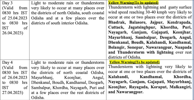
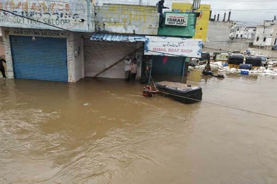
    Jaipur: After cyclone Biparjoy triggered floods in many districts of Rajasthan, the Met department has now sounded orange alert in Sawai Madhopur, Bundi and Tonk and yellow alert in places like Jaipur, Dholpur, Karauli, Bharatpur, Dausa, Kota, Baran, Jhalawad and Sikar.

    As per Met department, it rained heavily in Dholpur and the data collected till 8:30 on Tuesday morning said that it rained 184 mm here while it rained 166.5 mm in Karauli, 149 mm in Ajmer, 55 mm in Bhilwara, 52 mm in Chittaurgarh.

    With the heavy rains in different-parts of the state, the temperature in almost all districts is under 40 degree Celsius except Shri Ganganagar where 41 degree Celsius was recorded. Also, the minimum temperature in almost all districts has gone under 30 degree Celsius.

    The IMD officials said, “The Low Pressure Area (Remnant of Cyclonic Storm ‘Biparjoy’) now lies over south-west Uttar Pradesh and adjoining areas of north-west Madhya Pradesh & north-east Rajasthan. The associated cyclonic circulation extends up to middle tropospheric levels.”

    Rains, thunderstorms and winds shall be recorded in places like Jaipur, Bharatpur, Ajmer, Kota, Udaipur and other places till June 24, they added.

  • Bhubaneswar Sizzles At 44.3 Degrees Celsius, IMD Issues Orange Warning

    Bhubaneswar Sizzles At 44.3 Degrees Celsius, IMD Issues Orange Warning

    Odisha’s capital Bhubaneswar on Monday sizzled at 44.3 degrees Celsius which is more than 8.3 degrees than the normal temperature while as many as 31 places across the state recorded temperatures of 40 degrees Celsius or more, the MeT office said.

    Temperature above 5 degrees Celsius than the normal temperature in the coastal area is considered a severe heatwave condition.

    The weather office issued an orange warning (be prepared) for the heatwave to severe heatwave conditions at a few places over the district of Jharsuguda, Sambalpur, Bargarh, Sonepur, Boudh, and Bolangir on Tuesday and Wednesday.

    It also issued a yellow warning (be updated) and said heatwave condition is very likely to prevail at one or two places over the district of Sundergarh, Keonjhar, Mayurbhanj, Angul, Dhenkanal, Deogarh, Kandhamal, Nuapada, Kalahandi, Nayagarh, Khurda, Cuttack, Ganjam and Jajpur, during the same period.

    The normal life across the state including the twin cities of Bhubaneswar and Cuttack (43.2) was severely affected due to
    heatwave condition and there seems to be no respite as the IMD forecast said similar weather will continue for two more days,

    The IMD said that the day temperature on Monday breached 45 degrees Celsius in two places. Sambalpur was the hottest place in the state at 46.1 degrees Celsius and it was followed by Hirakud at 45.6 degrees Celsius and Sonepur at 45 degrees Celsius.

    While Bargarh recorded 44.9 degrees Celsius, Bolangir, Boudh, Titlagarh, Nayagarh, and Talcher registered 44 degrees Celsius. It was followed by Angul (43.9), Jharsuguda (43.4), Rourkela (43.2), Dhenkanal, Cuttack, and Nuapada (43.2).

    Bhubaneswar encountered both hot and humid conditions as the temperature soared to 44.3 degree Celsius and humidity level was at 88 per cent.

    The IMD said that there is no large change in maximum temperature (day temperature) during the next five days at many places in the state. Rather, it is likely to be above normal by 4-7 degree Celsius at a few places during the period, it said.

    The weather office also forecast thunderstorms with lightning very likely at one or two places over the districts of Malkangiri, Koraput, Nabarangpur, Kalahandi, Gajapati, Ganjam, Keonjhar, Mayurbhanj, Balasore, and Bhadrak.

  • Rain and storm: Orange alert issued for 11 districts

    Rain and storm: Orange alert issued for 11 districts

    Bhubaneswar: The Meteorological Centre here today issued an orange warning for rain accompanied by thunderstorms with lightning over 11 districts of Odisha.

    Thunderstorms with lightning and gusty surface wind speed reaching 40-50 kmph with hailstorms very likely to occur at one or two places over the districts of Kalahandi, Rayagada, Koraput, Kandhamal, Ganjam, Cuttack, Jajpur, Bhadrak, Dhenkanal, Angul, Boudh till tomorrow morning, informed the weatherman.

    Meanwhile, the people of the above-mentioned districts have been advised to keep watch on the weather and take safe shelter during the thunderstorm activity to protect from lightning and follow traffic advisories in urban areas. Harvesting of Rabi crops may be regulated judicially.

    Likewise, yellow warning for thunderstorms with lighting and gusty surface wind speed reaching 40-50 very likely to occur at one or two places over the districts of Balasore, Bhadrak, Jajpur, Kendrapara, Cuttack, Jagatsinghpur, Puri, Khurda, Nayagarh, Ganjam, Gajapati, Mayurbhanj, Keonjhar, Dhenkanal, Angul, Boudh, Kalahandi, Nabarangpur, Kandhamal, Koraput, Rayagada, Nuapada till 8.30 AM tomorrow.

    Similarly, thunderstorm with lightning is very likely to occur at one or two places over the rest districts of Odisha.

  • Orange Alert: Heavy rain, hailstorm and strong winds in Odisha

    Orange Alert: Heavy rain, hailstorm and strong winds in Odisha

    Bhubaneswar: Odisha is likely to experience an increase in thunderstorm activity with lightning accompanied by rain, isolated hail, heavy rain and gusty surface wind speed reaching 40-50 kmph during the next 2 -3 days, the India Meteorological Department informed on Sunday.

    Orange alert has been issued for some places in Kalahandi, Rayagada, Koraput, Kandhamal, Boudh, Ganjam, Cuttack, Jajpur, Bhadrak, Dhenkanal and Angul districts, which may witness thunderstorm with lightning, hail and gusty surface wind speed reaching 40-50 kmph till 8.30 am on Monday.

    The IMD has also sounded yellow alert for thunderstorm with lightning and gusty surface wind speed reaching 40-50 kmph at one or two places in Balasore, Kendrapada, Cuttack, Khurda, Puri, Nayagarh, Ganjam, Gajapati, Mayurbhanj, Keonjhar, Boudh, Nabarangpur and Nuapada. The rest districts may also experience thunderstorm and lightning.

    Light to moderate rain or thunderstorm is also likely at many places in South Odisha, North Coastal Odisha and at a few places in the remaining parts of the state during this period.

    The orange warning continues for another 24 hours with thunderstorm with lightning, hail and gusty surface wind speed reaching 40-50 kmph and heavy rainfall at one or two places in Cuttack, Dhenkanal, Jajpur, Kalahandi, Kandhamal, Mayurbhanj, Kendrapada, Bhadrak, and Balasore. Thunderstorm with lightning and gusty surface wind speed reaching 40-50 kmph is also likely at one or two places in Jagatsinghpur, Khurdha, Puri, Ganjam, Gajapati Angul, Keonjhar, Deogarh, Sundargarh, Sambalpur, Balangir, Sonepur and Boudh. There is also a forecast for light to moderate rain for the entire state.

    On April 25, yellow warning for thunderstorm with lightning and gusty surface wind speed reaching 30-40 kmph has been issued for one or two places in Bhadrak, Balasore, Jajpur, Kendrapada, Cuttack, Jagatsinghpur, Khurda, Puri, Nayagarh, Ganjam, Gajapati, Keonjhar, Mayurbhanj, Sambalpur, Deogarh, Angul, Dhenkanal, Boudh, Kalahandi, Kandhamal, Balangir, Sonepur, Nabarangpur and Nuapada. Light to moderate rain or thunderstorm is also likely at many places in North Odisha, South Coastal Odisha and at a few places in interior districts of South Odisha.

    Though yellow warning continues for another two days, there will be a decrease in the thunderstorm activity.